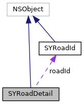
Represents a road on the route.
More...
#import <SYRoutingRoadDetail.h>
Represents a road on the route.
◆ GetDirectionAtTimeBlock
| - (typedef void(^ GetDirectionAtTimeBlock) (SYRoadDirection direction)) |
|
protected |
◆ GetSpeedLimitAtTimeBlock
| - (typedef void(^ GetSpeedLimitAtTimeBlock) (SYSpeed speedLimit)) |
|
protected |
◆ GetIsOpenAtTimeBlock
| - (typedef void(^ GetIsOpenAtTimeBlock) (BOOL isOpen)) |
|
protected |
◆ getDirectionAtTime:completion:
Get direction of road in defined time.
- Parameters
-
| time | Time at which the requested road restriction should be retrieved |
| completion | final call with retrieved direction |
◆ getSpeedLimitAtTime:orientation:profile:completion:
| - (void) getSpeedLimitAtTime: |
|
(nonnull NSDate *) |
time |
| orientation: |
|
(SYRoadOrientation) |
orientation |
| profile: |
|
(nonnull SYVehicleProfile *) |
profile |
| completion: |
|
(nonnull GetSpeedLimitAtTimeBlock) |
completion |
|
|
| |
Get direction of road in defined time.
- Parameters
-
| time | Time at which the requested road restriction should be retrieved |
| orientation | orientation of road in map, could be retrieved from route element |
| profile | logistic vehicle profile |
| completion | final call with retrieved speed limit |
◆ getIsOpenAtTime:orientation:profile:restrictions:completion:
Get direction of road in defined time.
- Parameters
-
| time | Time at which the requested road restriction should be retrieved |
| orientation | orientation of road in map, could be retrieved from route element |
| profile | logistic vehicle profile |
| restrictions | dimensional vehicle restrictions, we allow only one restriction per type, otherwise behaviour is undefined |
| completion | final call with retrieved value, if road is open |
◆ roadId
◆ country
| - (SYCountryIso*) country |
|
readnonatomicassign |
Represents country iso code.
◆ length
The lenght of the road on route.
◆ type
Represents a type of the road on route.
◆ attributes
| - (NSSet<NSNumber*>*) attributes |
|
readnonatomicassign |
The collection of SYRoadAttribute.
◆ geometry
Represents a collection of coordinates on the road.
◆ speedLimit
The speed limit in kmh, or 0 if the information is not available.
◆ roadName
The name of the road, or an empty string if the data is not available.
◆ cityName
The name of the city, or an empty string if the data is not available.
◆ areaName
The name of the area, or an empty string if the data is not available.
The documentation for this class was generated from the following file:

